
Fort Lauderdale, FL, USA

Fast-Tracking Climate Resiliency

Project Type:
Community Engagement, Environment, Infrastructure and Utilities

At a Glance


25.6” – Amount of rainfall recorded in Fort Lauderdale on April 12th, 2023, a new one-day record for the city.


$500 million – Cost of stormwater infrastructure improvements planned across 25 Fort Lauderdale neighborhoods over the next 10 years.

On April 12th, 2023, Fort Lauderdale was unexpectedly inundated by a 1-in-1,000 year storm. More than two feet of rain fell in just 12 hours, the most ever recorded there in a single day. Stormwater infrastructure was designed to handle a maximum of three inches of rain in 24 hours and was quickly overwhelmed, flooding wide swaths of the city of about 189,000 on Florida’s southeastern coast. More than 1,000 homes and City Hall were severely damaged, with water chest-deep in some places.

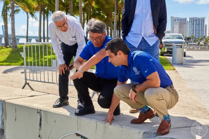
The unprecedented precipitation coupled with a very high tide underscored how climate change makes storms both more intense and less predictable. For Mayor Dean Trantalis and his leadership team, it also made clear the City needed to make Fort Lauderdale’s stormwater infrastructure stronger—and they needed to do it now.

A flooded street in Fort Lauderdale where climate change is creating more intense and unpredictable storms. Image Courtesy of the City of Arlington.

“We use data to think about everything. It’s all data-driven, from flood mapping and risk modeling to infrastructure planning and asset management. And now we’re really starting to tackle the challenge of figuring out what’s going to flood, when and where.”

Dr. Nancy Gassman, Deputy Director of Public Works

“Prioritizing the right climate adaptation projects requires careful location-specific risk assessments. I’m proud of our enhanced infrastructure strategy, and I’m proud that Fort Lauderdale is being recognized through What Works Cities Certification for putting data at the center of our climate resilience work.”

Fort Lauderdale Mayor Dean Trantalis

In November 2023 at the State of the City address, the mayor unveiled Fortify Lauderdale, a $500 million initiative to speed up and expand flood-prevention infrastructure projects across the city through 2034. The City had already been planning to upgrade infrastructure in eight neighborhoods before the April 2023 flooding. After the disaster, leaders ramped up data gathering efforts to identify high-risk areas and refine stormwater infrastructure plans for another 17 neighborhoods.

During Phase 1of the Stormwater Master Planning effort, city employees and consultants attended neighborhood association meetings asking residents to mark up a map detailing exactly where flooding occurred. They also gathered flooding data from residents who called the city’s customer service hotline. Internally, the City conducted a comprehensive stormwater asset management inventory, leaning on its GIS team to detail not just the location of every drain and pipe but also all maintenance work done on each piece of infrastructure in recent years.

All of this data informed the citywide stormwater master planning effort, which allowed leaders to prioritize infrastructure projects based on specific needs and risk levels. The result: 25 additional neighborhoods will see flood prevention upgrades over the next decade, more than triple the number that had been set to receive improvements prior to 2023.

“We have to manage through data given the organization’s finite resources. The ability to segment and analyze data in targeted ways is crucial for navigating where resources should go.”

Susan Grant, Acting City Manager, Fort Lauderdale

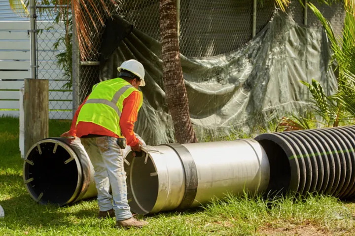
As of August 2024, about half of Phase 1 of the Stormwater Master Plan neighborhoods were complete or in construction. Spanning eight neighborhoods, the plan provides 50 miles of new stormwater pipe, 10 new stormwater pump stations, higher seawalls and enhanced swales, among other improvements. These will help get water out of neighborhoods faster, preventing costly damage. The new stormwater improvements are expected to improve the drainage capacity from 3 inches of rain in 24 hours to 7-10 inches. Fortify Lauderdale also includes developing guidelines that will strengthen outreach to owners of vulnerable properties to help them improve their own climate resilience practices. Together, these efforts are showing residents that when the next storm comes, the City can reduce the intensity, duration and frequency of flooding to roads passable, protect homes and prevent life-changing damage.

“A successful infrastructure resilience strategy needs to be anchored in community engagement and solid data,” Mayor Trantalis says. “We’re determined to maximize the value of every dollar we spend on these projects—there’s no time to waste.”

Join Our Certified Cities!

Port St. Lucie, Florida

Residents Tag Mobility as Priority. Port St. Lucie Uses Data to Deliver.

Project Type:
Community Engagement, Infrastructure, Public Safety, Transportation

At a Glance


In 2023, launched a newly formatted Port St. Lucie Stat program, moving from an annual review of operations to quarterly reviews. 


Collects resident input through an annual Citizen Summit and National Community SurveyTM.


In response to resident demand for better mobility options, the City  developed and found funding streams to support a Sidewalk Master Plan, Multimodal Plan and Mobility Plan.


Anticipating new jobs bringing over 9 million sq. ft. of new office, retail, research and industrial developments, the City created a jobs corridor with public art and green space requirements.

Port St. Lucie is one of the fastest growing cities in the country, adding more than 35,000 new residents in the past three years. This rapid growth comes with benefits and challenges. But, with the help of data and resident input, the Mayor, City Council and staff are successfully managing today’s growth and planning for the future. 

At the heart of their efforts is Port St. Lucie’s strategic plan. First developed in 2013, the plan is updated annually to reflect residents’ priorities as gathered at the #IAMPSL Citizen Summit and through a National Community Survey(NCS)TM. The City strives to make the Citizen Summit fun and easy for residents to attend – approximately 800 people came in 2023. The NCSTM takes a different approach for reaching residents. Run by the National Research Center at Polco, the survey is sent to a scientifically random sampling of households. 

For several years now, residents have made it clear – at both the Citizen Summit and through the NCSTM – that improving mobility around the city should be a priority. In 2023, only 4 in 10 residents said it was easy to walk around the city and even fewer thought it was easy to bike or use public transit. These findings are not necessarily surprising. Port St. Lucie was developed as a retirement community in the 1960s and included few sidewalks. But, in line with resident feedback, the City has made adding more sidewalks a key infrastructure priority in its strategic plan. 

In 2017, the City Council approved an enhanced  10-year Sidewalk Master Plan to add 35 miles of sidewalks, particularly on streets within a two-mile radius of schools, and to create a network of connected sidewalks. Progress on the plan has been helped by a resident-approved half-cent sales tax increase for infrastructure projects. As with its other strategic goals, the City tracks its performance on the Sidewalk Master Plan on a public dashboard. It also recently revamped its Port St. Lucie Stat program to meet quarterly and to align with best practices on strategic planning and establishing performance metrics. This allows the Public Works and Police Departments to better collaborate on mobility solutions in response to traffic data. The Police Department also has a Stat program in place as part of their data-informed approach.

In 2022, the City installed 4.9 miles of new sidewalks and repaved 49.94 miles of roads.

And the City has not stopped with the Sidewalk Master Plan. In 2021, it began exploring multimodal planning as a way to increase sidewalk connectivity, expand transit coverage, reduce congestion, and accelerate street repairs and improvements. State legislation allows local governments with multimodal plans to collect flexible mobility fees on new developments instead of road-specific impact fees. The City adopted both a Multimodal Plan and a Mobility Plan in order to access this flexible funding. As of September 2023, the City had collected $22 million in mobility fees to invest in projects that will have the biggest impact for current and future residents. 

“The City of Port St. Lucie has a strategic plan to bring the City towards an even better future. Each year, our nationally award-winning planning process begins with listening to the input and ideas of Port St. Lucie residents. Through this process, residents can truly help shape the future of their City.”

Kate Parmelee, Deputy City Manager for Strategic Initiatives & Innovation

“Basically everything we do here is based on our strategic plan.”

Shannon Martin, Mayor

According to the U.S. News & World Report #2 safest city to live in the U.S.

Join Our Certified Cities!

Miami, Florida, USA

Crowdsourced Data Boosts Miami Climate Resiliency Efforts.

Project Type:
Community Engagement, Environment, Infrastructure, Technology

WWC - Silver Certification Badge for year 2021

At a Glance


Created an app for residents to report flooding on their streets, creating an influx of crowdsourced data that the City could act upon.


Received data from mapped geolocation spots that identified neighborhoods needing infrastructure improvements.


Accessed satellite images through Google’s Environmental Insights Explorer that guided streetscape planning and reduced runoff and flood levels.

Miami’s Weather

Given Miami’s extensive coastline and frequent tropical storms, city officials are accustomed to hearing from residents when streets flood. Yet until recently, most of the complaints they received came from people who lived close to the ocean — often in affluent communities.

That meant help was being provided unevenly. “It was like the squeaky wheel gets the attention,” says Melissa Hew, resilience programs manager in Miami’s Department of Resilience & Public Works.

But Miami’s approach to managing floodwaters and the broader impacts of climate change has changed since work began three years ago on the Miami Forever Climate Ready plan. The collaborative effort convened stakeholders and local experts to make Miami more resilient to growing threats — including more frequent and intense floods, storms, and high-heat days. A main goal of the plan, published in January 2020, is to make decisions based on data-driven assessments, including historic and crowdsourced data, to ensure a methodical and equitable approach. Another is engaging stakeholders (especially residents) and incorporating their feedback into the plan and its implementation.

Miami Mayor Francis Suarez takes a close look at part of the City’s coastal infrastructure. Photo courtesy of the City of Miami.

Both of those goals have guided Miami’s partnership with ISeeChange, a company that created an app in partnership with the City to make it easy for residents to report flooding on their streets. Since it launched in July 2020, data crowdsourced through the app has been used in several ways to guide flood response and remediation efforts.

The most immediate impact involved maintenance crews. When residents report incidents through the app, the Department of Public Works can send crews out to address the flooding, which is often due to a clogged drain or other obstruction.

“Because we don’t have enough inspectors, these residents have been our eyes on the street. It’s been extremely helpful.”

Resilience Programs Manager Melissa Hew

Data received from the app is also mapped using geolocation, allowing the city to notice patterns and identify neighborhoods that require infrastructure improvements. That’s particularly important in disaster preparedness efforts, Hew notes, including capital project planning. “Having this data gives us an upper hand: We have a better idea of what’s to come,” she says. “We know what the flooding will look like, and we know the type of infrastructure we need to put in place,” such as stormwater systems.

“We didn’t hear as much from the folks inland, even though they tend to be equally if not more affected by climate hazards.”

Resilience Programs Manager Melissa Hew

A Community Engagement Upgrade

When the City released its stormwater master plan last year, the app also came in handy on the stakeholder engagement front. In addition to in-person meetings where residents could point out flood-prone areas on a map, the app offered another touchpoint to ask community members what they were experiencing and collect their feedback.

“We went to the community to see if the forecasting models were validated by what the residents were seeing,” Hew says.

A Miami Department of Resilience & Public Works employee works on a stormwater project. Photo courtesy of the City of Miami.

The app also guides the Department of Resilience & Public Works’ outreach efforts. It doesn’t reach all Miami residents, since some lack access to reliable internet access or have limited English proficiency. (A Spanish-language version of the app is also available.) But by seeing which neighborhoods have low levels of engagement in the app, Hew and her colleagues can tell their community managers to focus in-person efforts in those areas.

“It’s not a total loss when we are not able to engage with them digitally. It highlights a different form of engagement we need to initiate.”

Resilience Programs Manager Melissa Hew

Her department utilizes data beyond the ISeeChange app as well. Through a pilot with Google’s Environmental Insights Explorer, the team has access to satellite images that detail Miami’s tree canopy. That is more granular data than the City has ever had, says Alissa Farina, who is also a resilience programs manager in the resilience department. She anticipates it will guide streetscape planning moving forward; trees can help reduce runoff and flood levels by absorbing water.

The hope is to pull together in one place all the data the City receives about how climate change affects residents. In addition to the app, residents can also provide information through email and 311. The larger goal is a central, GIS-based database that all city departments can access and pull from, Farina says. This resource would be maintained by the Department of Innovation and Technology (DoIT), which leads Miami’s data-related efforts, and help improve capital project planning, emergency management, and implementation of climate-related programs, among other things.

With the effects of climate change likely to intensify in the coming decades, the stakes are high for Miami’s resiliency efforts. But the City’s commitment to foundational data-driven practices, especially stakeholder engagement and data governance, is already yielding clear benefits.

“Being serious about resilience means being serious about data-driven assessments and decision-making, in my view. We’re in the early stages of this effort, but we’ve already developed invaluable new ways of gathering, analyzing and acting on data. As a city on the frontlines of climate change, there’s no time to waste.”

CIO & Director of DoIT Michael Sarasti

Join Our Certified Cities!

Disclaimer