Norfolk, Virginia, USA
Building Climate Resilience Through Data Infrastructure in Norfolk.
Project Type:
Community Engagement, Communication, Environment, Health-Wellness, High-Performing Government, Technology

2025 Gold Certification
“The City of Norfolk is honored to have maintained the What Works Cities Gold Certification, a testament to our commitment to data-driven excellence and innovation. We are proud to have strengthened transparency, improved efficiency and enhanced services that directly benefit our residents and businesses. This recognition reflects the hard work of our employees and our dedication to making Norfolk a more responsive, accountable and forward-thinking city.”
2023 Gold Certification and 2024 Gold Certification
Norfolk hosted a “Datathon” that led to tree canopy recommendations to reduce extreme heat for low-income residents. The City’s CivicLab hosted its first annual Datathon in 2022. Using publicly available data, including tree canopy data from the City of Norfolk, the winners developed a model to better understand and assess demographic equity of extreme heat and direct sunlight exposure due to lack of tree canopies. Their work has been published in a peer-reviewed journal and now helps Norfolk’s tree planting program prioritize neighborhoods with shade inequity. In 2023, The Forest Service awarded Norfolk a grant to increase tree canopies in underserved communities. By empowering and facilitating data-driven solutions from residents, Norfolk is improving public health and creating a more climate-resilient city.
2021 Silver Certification
Developed and launched STORM, an app that displays data collected by residents and City staff during a storm event detailing flooded streets, downed power lines, and other problems.
Improved resident decision-making around flood risk by allowing them to look up their property to identify the risk of flood across their mortgage period.
Collected and analyzed data for Norfolk City Council to demonstrate which neighborhoods are in need of more local, healthy grocery options.
Data Helping Norfolk Weather the Storm
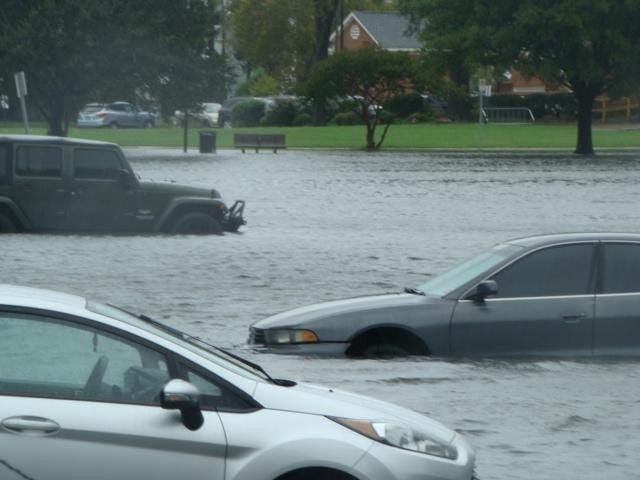
Tropical Storm Elsa battered the east coast of the United States in July 2021, slamming cities like Norfolk, Virginia with 50 m.p.h. winds and heavy rainfall. With more than 50 million people under flash flood warning, local governments sprang to work, preparing for potential damage caused by the storm. Luckily for the residents of Norfolk, the City’s long-term investment in data infrastructure prepared them well.
For cities like Norfolk, water is king. Boasting the world’s largest naval station, the City’s port and maritime areas have been an economic and cultural hub for hundreds of years. While water is a source of opportunity in Norfolk, it is also a source of challenges. With climate change bringing rising sea levels and an increase in extreme weather events, the coastal city is experiencing more frequent flooding. But thanks to the City’s investment in an in-house data and innovation team, CivicLab, and its robust Open Data portal, Norfolk is better equipped than most to gather real-time storm data and translate it into informed action.
“Through CivicLab, we connect employees and residents to data, create tools for analyzing this data, and catalyze exploratory work that offers new approaches to local government. Applying this approach to resilience efforts is critical to how Norfolk addresses challenges like Tropical Storm Elsa.”
A Two-Pronged Strategy
Norfolk’s data-driven resilience strategy is a two-pronged approach that focuses on both residents and the City’s own flood management efforts. On the external side, IT developed and launched STORM, an app that displays data collected by residents and City staff during a storm event detailing flooded streets, downed power lines, and other problems. The data from this tool was later posted to the Open Data Portal so everyone could access it.
In March 2021, the City took its resilience efforts to the next level with the launch of the Flood Risk Learning Center. Expanding on the City’s successful TITAN application, which shows residents the flooding levels from past storm benchmarks based on the Norfolk Tide Gauge dashboard, the new Learning Center gives residents the ability to generate personalized flood risk reports based on their building address. Reports also include FEMA resources and tips to lower flood insurance costs.
Built with Civis Analytics, the Learning Center incorporates audience-specific messaging to improve resident decision-making around flood risk. By allowing people to look up their property and identify the risk of flood across their mortgage period, the information has more impact. “When you give them information like: ‘There is a 96 percent chance of 1.25 feet of flooding happening during your 30-year mortgage’ — that’s when you see the aha moment,” says Matt Simons, principal planner in the City’s Planning Department.
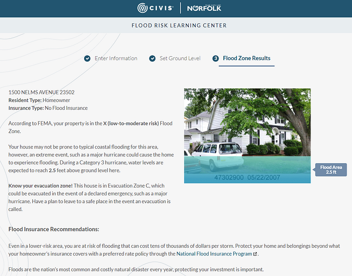
Even during its pilot phase, the Learning Center’s improved floodplain mapping services was partially responsible for Norfolk’s increased score in FEMA’s National Flood Insurance Program (NFIP) Community Rating System (CRS), which incentivizes communities to go beyond minimum NFIP flood management practices. The City is a top CRS community in Virginia and in the top 10 percent of cities nationwide. This increased score has translated into a 25 percent reduction in the premium for Norfolk’s flood insurance policyholders, amounting to $2.5 million in annual savings — about $200 per policyholder.
“Through the Learning Center, we are translating data to help people make improvements to their properties that reduce flood risk, buy more appropriate flood insurance plans, and save money on their existing policies,” Simons says.
The most tangible improvements made through Norfolk’s resilience strategy may be in the City’s impressive system of tide gauges. Before their installation, staff had to monitor certain areas for flood risk, driving around to visually check for rising waters. Now, every six minutes, tide gauges record a water level reading. Data flows to the Tide Gauge dashboard, helping the City determine when to close its flood gates. All of this is done remotely by staff monitoring flood risks in real-time. They’re able to efficiently dispatch crews to targeted areas for mitigation efforts and alert residents about flood risks (or actual flooding) via digital devices.
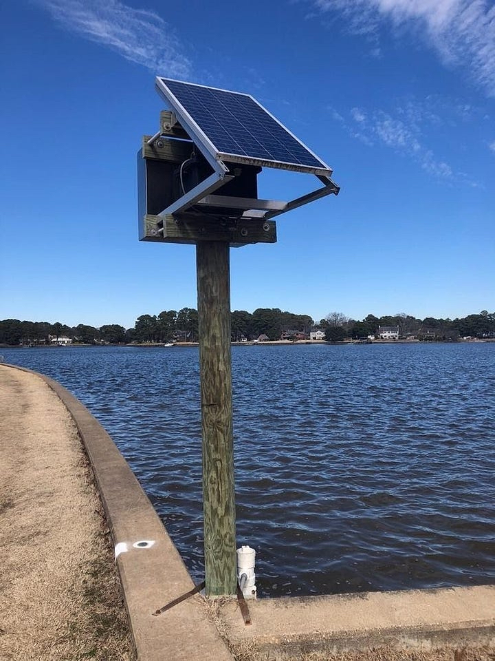
In neighborhoods plagued by regular flooding — like Tidewater Gardens adjacent to downtown — these sensors are informing plans for new stormwater systems that incorporate more drainage systems, pump stations, and green space for rainwater absorption. All of this data is stored for long-term use, helping to inform engineers’ designs and predict water levels 36 hours out. Another benefit of the data: It helped the City and state win large grants, including a $100 million flood control project via the U.S. Department of Housing and Urban Development.
A Strong Foundation, Then Results
Norfolk’s data-informed resilience work is built upon the City’s long-standing commitment to building a data culture that prizes foundational practices like stakeholder engagement, open data, and performance & analytics. Starting in 2017 with guidance from What Works Cities (WWC), Norfolk developed an open data policy, formed a data leadership committee with members from across departments, and selected data champions to train others. WWC introduced the team to Sunlight Foundation, which selected Norfolk as a pilot city to expand its use of open data outside of City Hall and into the communities it serves. One example of this: For each new data set made public, the City writes a data story to help explain how the stats impact residents.
To help better organize ongoing efforts, city staff pitched the idea of an in-house data and innovation team to City Manager Larry “Chip” Filer. Filer quickly agreed to support the new group, and CivicLab was born. Since then, CivicLab’s efforts have steadily grown.
It had also applied the City’s extensive data infrastructure to address a range of challenges, such as improving Norfolk’s COVID-19 vaccine rollout. CivicLab helped identify possible locations for vaccine pre-registration and mobile clinics, pinpointed census tracts with low vaccination rates and socially vulnerable populations, and tracked current vaccination rates across the City. Norfolk then successfully used this data to convince FEMA to establish a vaccine supersite in the City, leading to the administration of an additional 83,571 shots. Another example of CivicLab’s data chops in action: Its team collected and analyzed data for Norfolk City Council to demonstrate which neighborhoods are in need of more local, healthy grocery options.
“With all of this work, we aim to use data to make better decisions. Our hope is to be a living laboratory for resilience, where well-informed ideas can really take off and accelerate.”
“Our partnership with What Works Cities helped City staff get comfortable with thinking of data as a citywide resource.”